1. Name of the publishing authority
The AIP Rwanda is published by authority of the Rwanda Civil Aviation Authority.
2. Applicable ICAO documents
The AIP is prepared in accordance with the Standards and Recommended Practices (SARPs) of Annex 15 to the Convention on International Civil Aviation and the ICAO Aeronautical Information Services Manual (Doc 8126).
Charts contained in the AIP are produced in accordance with Annex 4 to the Convention on International Civil Aviation and the ICAO Aeronautical Chart Manual (Doc 8697). Differences to ICAO Standards, Recommended Practices and Procedures are given in subsection GEN 1.7
Charts contained in the AIP are produced in accordance with Annex 4 to the Convention on International Civil Aviation and the ICAO Aeronautical Chart Manual (Doc 8697). Differences to ICAO Standards, Recommended Practices and Procedures are given in subsection GEN 1.7
3. Publication Media
The AIP Rwanda is published in one volume, on a printed loose-leaf paper form, online in both HTML and printable PDF versions and on CD-ROM or DVD. All aeronautical information documents are available on Rwanda Civil Aviation Authority website (
www.caa.gov.rw) and ASECNA AIM Portal (
aim.asecna.aero/html/index-fr-FR.html)
4. The AIP structure and established regular amendment interval
4.1 The AIP Structure
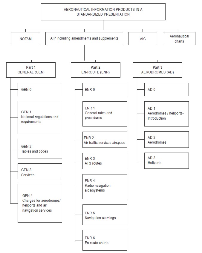
The AIP forms part of the Aeronautical Information Products, details of which are given in subsection GEN 3.1. The principal AIP structure is shown in graphic form on page GEN 0.1-3. The AIP is made up of three parts, General (GEN), En-route (ENR) and Aerodromes (AD), each divided into sections and subsections as applicable, containing various types of information subjects.
4.1.1 Part 1 - General (GEN)
Part 1 consists of five sections containing information as briefly described hereafter.
GEN 0 — Preface; Record of AIP Amendments; Record of AIP Supplements; Checklist of AIP Pages; List of Hand Amendments to the AIP and the Table of Contents to Part 1.
GEN 1. National Regulations and Requirements—Designated Authorities; Entry, Transit and Departure of Aircraft; Entry, Transit and Departure of Passengers and Crew; Entry, Transit, and Departure of Cargo; Aircraft Instruments, Equipment and Flight Documents; Summary of National Regulations and International Agreements/Conventions; and Differences from ICAO standards, Recommended Practices and Procedures.
GEN 2. Tables and Codes — Measuring System, Aircraft Markings, Holidays; Abbreviations used in AIS Publications; Chart Symbols; Location Indicators; List of Radio Navigation Aids; Conversion Tables and Sunrise/Sunset Tables.
GEN 3. Services — Aeronautical Information Services; Aeronautical Charts; Air Traffic Services; Communication Services; Meteorological Services and Search and Rescue.
GEN 4. Charges for Aerodromes and Air Navigation Services — Aerodrome Charges; Air Navigation Service Charges.
4.1.2 Part 2 — En route (ENR)
Part 2 consists of seven sections containing information as briefly described hereafter.
ENR 0. Table of Contents to Part 2.
ENR 1. General Rules and Procedures — General Rules; Visual Flight Rules; Instrument Flight Rules; ATS Airspace Classification; Holding, Approach and Departure Procedures; Radar Services and Procedures; Altimeter Setting Procedures; Regional Supplementary Procedures (Doc 7030); Air Traffic Flow Management (ATFM); Flight Planning; Addressing of Flight Plan Messages; Interception of Civil Aircraft; Unlawful Interference; and Air Traffic Incidents.
ENR 2. Air Traffic Services Airspace — Detailed description of Flight information regions (FIR); Upper Flight Information Regions (UIR); Terminal Control Areas (TMA); and Other Regulated Airspace.
ENR 3. ATS Routes — Detailed description of Conventional Navigation Routes; Area Navigation (RNAV) Routes; Other Routes; and En-route Holding.
ENR 4. Radio Navigation Aids/Systems Radio Navigation Aids - En-route; Special Navigation Systems; Global Navigation Satellite System (GNSS); Name - Code Designators for Significant Points; and Aeronautical Ground Lights - En-route.
ENR 5. Navigation Warnings — Prohibited, Restricted and Danger Areas; Military Exercise and Training Areas; Other Activities of a Dangerous Nature and Other Potential Hazards; Air Navigation Obstacles - En-route; Aerial Sporting and Recreational Activities; and Bird Migration and Areas with Sensitive Fauna.
ENR 6. En-route Charts — Air Traffic Service System - En-route Chart - ICAO; Area Navigation (RNAV) - En-route Chart - ICAO; Prohibited, Restricted and Danger Areas –Index Chart.
4.1.3 Part 3 – Aerodromes (AD)
Part 3 consists of four sections containing information as briefly described hereafter.
AD 0. Table of Contents to Part 3.
AD 1. Aerodromes/Heliports - Introduction
Aerodrome/Heliport Availability; Rescue and Fire Fighting Services and Snow Plan; Index to Aerodromes and Grouping of Aerodromes.
AD 2. Aerodromes
Detailed Information about Aerodromes including Helicopter Landing Areas, if located at the aerodromes, listed under 24 subsections.
AD 3. Heliports
Detailed Information about Heliports (not located at aerodromes), listed under 23 subsections.
4.2 Regular Amendment Interval
Regular AIP amendments (AIP AMDT) will be issued once a year. The publication date will be on the first day of August of each year.
4.1.1 Part 1 - General (GEN)
GEN 2. Tables and Codes — Measuring System, Aircraft Markings, Holidays; Abbreviations used in AIS Publications; Chart Symbols; Location Indicators; List of Radio Navigation Aids; Conversion Tables and Sunrise/Sunset Tables.
GEN 3. Services — Aeronautical Information Services; Aeronautical Charts; Air Traffic Services; Communication Services; Meteorological Services and Search and Rescue.
GEN 4. Charges for Aerodromes and Air Navigation Services — Aerodrome Charges; Air Navigation Service Charges.
ENR 0. Table of Contents to Part 2.
ENR 1. General Rules and Procedures — General Rules; Visual Flight Rules; Instrument Flight Rules; ATS Airspace Classification; Holding, Approach and Departure Procedures; Radar Services and Procedures; Altimeter Setting Procedures; Regional Supplementary Procedures (Doc 7030); Air Traffic Flow Management (ATFM); Flight Planning; Addressing of Flight Plan Messages; Interception of Civil Aircraft; Unlawful Interference; and Air Traffic Incidents.
ENR 2. Air Traffic Services Airspace — Detailed description of Flight information regions (FIR); Upper Flight Information Regions (UIR); Terminal Control Areas (TMA); and Other Regulated Airspace.
ENR 3. ATS Routes — Detailed description of Conventional Navigation Routes; Area Navigation (RNAV) Routes; Other Routes; and En-route Holding.
ENR 4. Radio Navigation Aids/Systems Radio Navigation Aids - En-route; Special Navigation Systems; Global Navigation Satellite System (GNSS); Name - Code Designators for Significant Points; and Aeronautical Ground Lights - En-route.
ENR 5. Navigation Warnings — Prohibited, Restricted and Danger Areas; Military Exercise and Training Areas; Other Activities of a Dangerous Nature and Other Potential Hazards; Air Navigation Obstacles - En-route; Aerial Sporting and Recreational Activities; and Bird Migration and Areas with Sensitive Fauna.
ENR 6. En-route Charts — Air Traffic Service System - En-route Chart - ICAO; Area Navigation (RNAV) - En-route Chart - ICAO; Prohibited, Restricted and Danger Areas –Index Chart.
4.1.3 Part 3 – Aerodromes (AD)
AD 0. Table of Contents to Part 3.
AD 1. Aerodromes/Heliports - Introduction
Aerodrome/Heliport Availability; Rescue and Fire Fighting Services and Snow Plan; Index to Aerodromes and Grouping of Aerodromes.
AD 2. Aerodromes
Detailed Information about Aerodromes including Helicopter Landing Areas, if located at the aerodromes, listed under 24 subsections.
AD 3. Heliports
Detailed Information about Heliports (not located at aerodromes), listed under 23 subsections.
4.2 Regular Amendment Interval
5. Copyright Policy
6. Service to contact in case of detected AIP error or omissions
In the compilation of the AIP care has been taken to ensure that the information contained therein is accurate and complete. Any errors and omissions which may nevertheless be detected, as well as any correspondence concerning the aeronautical information products should be referred to:
Direction de l'exploitation de la Navigation Aerienne
Service AIM
B.P. 3144 - Dakar - Senegal
E-mail : dnaai@asecna.org
or to:
Tel 2: +250 - 724 – 123 076
E-mail: kiaaim@asecna.org or
gatsinzicha@asecna.org
Kigali – Rwanda
And to:
Rwanda Civil Aviation Authority
P.O. Box 1122, Kigali
Tel: +250 - 252 – 585 845
E-mail: aip@caa.gov.rw
Service AIM
B.P. 3144 - Dakar - Senegal
E-mail : dnaai@asecna.org
or to:
Tel 2: +250 - 724 – 123 076
E-mail: kiaaim@asecna.org or
gatsinzicha@asecna.org
Kigali – Rwanda
And to:
Rwanda Civil Aviation Authority
P.O. Box 1122, Kigali
Tel: +250 - 252 – 585 845
E-mail: aip@caa.gov.rw